
Page last updated or reviewed: June 1, 2015 (review only)
The section between I-30 and West Main (Highway 180) required a large clearance through a residential area. Several commercial properties near I-30 were also displaced. The clearance was nearly complete at the time these photos were taken in 2004.
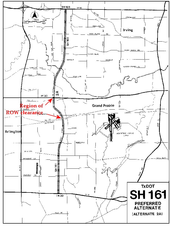
This map shows the area where the major right-of-way clearance took place. However, the area shown in these photos was not the neighborhood which filed the lawsuit against the project. The neighborhood filing the lawsuit was on the northwest side of the I-30/Bush Turnpike interchange. The 1983 lawsuit resulted in a 1985 court injunction which prevented further work. The injunction was lifted in 1998, and an appeals court ended legal action in 2000 by ruling in favor of the freeway.
Cleared right-of-way north of Main Street. Only one structure remained, visible in the distance
(Photo date: 14-March-2004)
A closer view of the remaining structure.
(Photo date: 14-March-2004)
(Photo date: 14-March-2004)
This home was prepared for transport.
(Photo date: 14-March-2004)
This slab remained along Dalworth street.
(Photo date: 14-March-2004)
Looking north along 14th Street, with the cleared area on the left.
(Photo date: 14-March-2004)
Home being cleared near 14th and Cain.
(Photo date: 14-March-2004)
Most of the houses on this street (probably Cain street) are cleared.
(Photo date: 14-March-2004)
Only slabs remain.
(Photo date: 14-March-2004)
Church about the be demolished.
(Photo date: 14-March-2004)
(Photo date: 14-March-2004)

Three months later the church was reduced to its main structural components.
(Photo date: 5-June-2004)

The church interior
(Photo date: 14-March-2004)
Home near the church being demolished.
(Photo date: 14-March-2004)
(Photo date: 14-March-2004)
This structure along 19th Street was vacated, awaiting demolition.
(Photo date: 14-March-2004)

Three months later, only the building's structural shell remained.
(Photo date: 5-June-2004)
A commercial area just south of I-30 was impacted. This strip center on Tarrant road east of 19th Street was boarded up.
(Photo date: 14-March-2004)
This Taco Bell was closed.
(Photo date: 14-March-2004)
Notice to customers
(Photo date: 14-March-2004)
The McDonalds was boarded up, awaiting demolition.
(Photo date: 14-March-2004)
This view looks north, approximately on the location of the center of the future main lanes of TX 161. The McDonalds is visible in the distance..
(Photo date: 14-March-2004)